Dear Elijah,
When I’m not answering science questions, you can usually find me at the river. I enjoy the cool water and tasty fish. And I really love the gentle breeze ruffling my fur.
I asked my friend Jun Meng about that wind. He’s an atmospheric scientist at Washington State University. He leads a lab that studies air quality. That includes wildfire smoke and dust that ride the wind.
He told me that wind is air on the move.
“Air moves because the sun doesn’t hit the Earth’s surface evenly,” Meng said. “Some places get warmer than others. When the air warms up, it rises. When it’s cool, it sinks.”
Air is mostly nitrogen and oxygen molecules. When they warm up, those air molecules move faster. They drift apart. Scientists say that the air expands.
Have you ever opened a car door on a super-hot day? You can feel the warm air rush out. The trapped air inside the car heated up and pushed outward. When the door opened, it flowed out.
When the air molecules are farther apart, there are fewer molecules in one space. The warm air is less dense. It rises above the cooler, heavier air.
When they’re cool, air molecules move more slowly. They crowd close together. That makes the air denser. Cooler, heavier air sinks.
“That leaves some spots with extra air piled up and other spots with less,” Meng said. “So, air just flows from where there’s more of it to where there’s less. And that flowing air is what we feel as wind.”
It’s like blowing a bunch of air into a balloon and pinching the neck closed. If you let go, the air flows out of the small balloon—where it’s packed in tight—and into the big room.
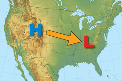
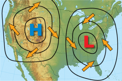
Scientists describe an area with air molecules packed together as high pressure. A place where they’re spread out is low pressure. So, air moves from high pressure to low pressure—like a slide called the pressure gradient. This weather map (right) shows black loops called isobars. Each loop connects places where the pressure is the same. If isobars are drawn close together, the pressure gradient is stronger. That means the wind will blow faster there. The arrows curve a little because the spinning Earth bends the wind’s path. @NOAA
Wind does important jobs.
Wind shifts warm air to help regulate the temperature all over the planet. It also moves moisture in the air, so it rains in different places. It can blow away smog and wildfire smoke.
Wind carries seeds, spores and pollen to new places. That helps plants spread. It pushes against young plants, encouraging them to grow stronger stems and roots.
Meng told me it even carries phosphorus-rich dust from the Sahara Desert all the way across the ocean to the Amazon rainforest. That replaces the nutrients washed away by tropical rains in the rainforest.
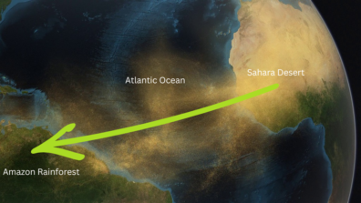
This pic from an animation shows dust blowing from Africa on the right over the Atlantic Ocean to land in South America. That’s a 3,000-mile journey! © NASA’s Goddard Space Flight Center, labels and arrow by Dr. Universe
It turns out the sun makes the breeze at the river, too. The land warms up faster than the water. So, air rises over the sand and sinks over the river. Then the cool air over the water flows toward the land. That’s the wind tousling my fur.
When the water is big—like an ocean—that cycle is big enough to get names. On a sunny afternoon, when the land is much warmer than the water, the wind blows from the sea toward the beach. That’s a sea breeze. At night, the land cools off faster, so the wind flips and blows back out to sea. That’s a land breeze.
It all works because air knows how to go with the flow.
Sincerely,
Dr. Universe